Northern Territory Info
Kakadu National Park
|
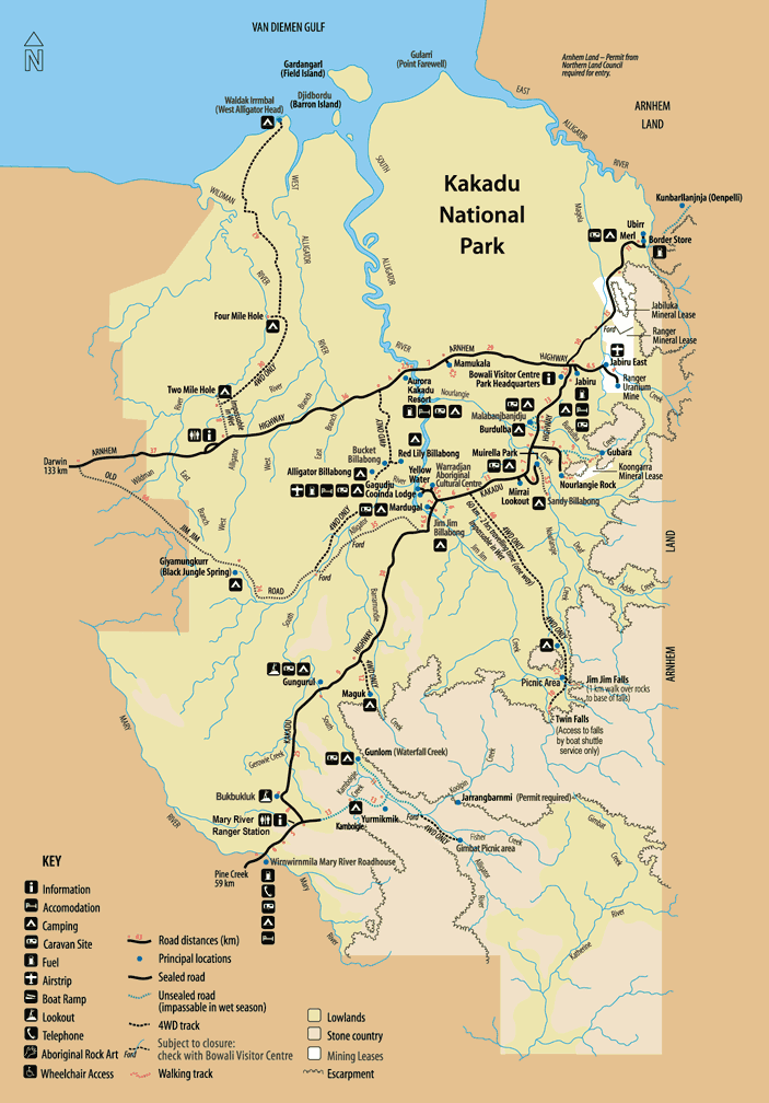
This World Heritage listed park characterised by exceptional galleries of Aboriginal art and diverse and fascinating wildlife. Kakadu National Park includes Jabiru, Nourlangie Rock, Ubirr, Jim Jim Falls, Twin Falls, Yellow Waters, the South Alligator River and Waterfall Creek Nature Park. Kakadu National Park is situated on the western side of the Arnhem Land Aboriginal Reserve in northern Australia. It has three main landscape regions-woodlands, which cover the largest area; rocky sandstone uplands in the south and east, rising above the plains; and floodplains in the north. The park takes its name from the Aboriginal inhabitants, the Gagudju people, who trace their ancestry back at least 50,000 years. One thousand Aboriginal rock painting sites have been identified so far in the park, and some of the paintings date from 35,000 years ago. Kakadu National Park is an internationally important wetland. Large populations of magpie geese, brolgas (crestless Australian cranes), egrets, and herons live in the park. There are also more than 50 species of mammal, about 275 species of bird, and more than 1,000 plant species.The Ranger Uranium Mine is located inside the park. |
||||||||||||||||||||
|
The starting point for any appreciation of Kakadu National Park is to eliminate any preconceptions you may have. No matter how many photographs you may have seen and no matter how many times you have watched the two Crocodile Dundee movies nothing will adequately prepare you for the discrepancy between the image and the reality. For most Australians 'tropical' means 'exotic rainforests' and 'World Heritage' equals 'area of great beauty'. The reality is that Kakadu, apart from a few small areas, is not tropical rainforest and that its World Heritage is based on its importance as a wetlands area not on its physical beauty. Like much of northern Australia, Kakadu is an area of flat tropical savanna woodland with a kind of grey, rather unattractive, monotony produced by a low scrubby vegetation and large tracts of undifferentiated flat terrain. This is not, for one moment, to suggest that it shouldn't be World Heritage listed. The abundance of wildlife, particularly birdlife, which flocks into the swampy areas of the park during the dry season demonstrates how important it is to the fauna of the area. It's just not an area of great beauty. As far as can be determined the term 'Kakadu' was given to the people of the Alligator River region by the noted anthropologist and biologist Sir Baldwin Spencer. It is in fact the language of the Aboriginal people who traditionally lived in the north western section of the park. Some authorities on the area have suggested that in the language of the local Aborigines 'Kakadu' or, as it is sometimes spelt, 'Kakudju' or 'Gagadju', doesn't have a specific meaning. The early history of white contact with the Kakadu area includes the visits of Baldwin Spencer in 1912, the subsequent visit of N. B. Tindale in 1928 and the establishment of the American-Australian Scientific Expedition to Arnhem Land in 1948. In 1954 UNESCO published a book of paintings from the area in a series on world art. Subsequent explorations have discovered many other valuable sites. The area around Kakadu is the site of some of the earliest tropical settlements in Australia and as such is of great archaeological importance. It is important to remember, when travelling through the area, that 25 000 years ago the Aborigines were far more artistically and industrially advanced than their counterparts in Europe and the Middle East. They had developed grinding stones for crushing seeds and were preparing ochre for painting on cave walls. On 5
April 1979, as part of the Commonwealth Commission of Inquiry into the
Ranger Mining Proposals, it was decided to set aside 6000 sq. km of Arnhem
Land under the National Parks and Wildlife Act. The park was to be managed
by the Australian National Parks and Wildlife Service. The area was
subsequently listed by the World Heritage and is now one of the most
important Heritage regions in Australia. At the moment it covers an area of
1 307 300 hectares of land. |
||||||||||||||||||||
|
1. The plateau is a huge, rugged sandstone formation which rises sharply to a height of 250 m from the lower lands to the north and produces some of the most spectacular scenery in the park. The dramatic escarpment extends for over 600 km and is the site of the major waterfalls and deep gorges in the park. The escarpment caves have been a natural shelter for the traditional owners of the region who have painted many of the caves with pictures of great antiquity and beauty. The plateau has been subjected to severe tropical weathering which has created honeycombing in the rock surfaces and exposed ancient rock formations. 2. The lowlands are a vast eroded plain with a few rocky outcrops which lie to the north of the escarpment. 3. The floodplain which lies to the north of the plateau is dramatic and beautiful. It receives the full force of the monsoonal rains which arrive in November and last until March and thus in the wet season is a vast expanse of water. In the dry season it is characterised by permanent billabongs. The area is famed for its waterlilies and lotus lilies which are edible. 4. Tidal flats. This area is a typical tropical wasteland where the salt water inundates the region making it suitable only for mangroves and rainforest which can thrive on sandy saline soils. 5. Southern hills and basins exist at the southern most point of the park near Fisher Creek. This is an area of woodland where the headwaters of the South Alligator River run through harsh stony country. Bounded to the north by Van Diemen Gulf and to the east and west by the Wild Man and East Alligator Rivers (the Alligator River was named by Phillip Parker King in 1820 who mistook the crocodiles in the area for alligators) Kakadu gained international publicity when it featured prominently in the two Crocodile Dundee movies. But it is the diversity of its fauna and flora rather than its brush with Paul Hogan which has really made the area important. It is worth remembering, as you drive through Kakadu, that the park contains over 1000 plant species, a quarter of all the freshwater fish species found in Australia, and over one-third of all the bird species. Add to this the thousands of insects and the whole park is a reminder that the tropics really are the breeding ground for the whole planet. It is hard to pick the ideal time to visit Kakadu. In the wet season large areas of the park are closed to the public. It would not be possible to enter or exit from the park via the Kakadu Highway. It would not be possible to visit Jim Jim or Twin Falls and, until the road is sealed, it would not be possible to go to Ubirr Rocks. There seems to be a consensus amongst the park's rangers that the best time to visit is at the end of the dry season when the birds are forced to congregate in the ever-diminishing wetland waterholes. During the dry season there is still selective burning off in Kakadu which means that the idea of leaving the area as a wilderness park is being conditioned by the controls of the National Parks and Wildlife. Ancient Rock Art |
||||||||||||||||||||
|
Up to five thousand Aboriginal art sites cover the walls of Kakadu’s caves and sheltered outcrops, ranging from thirty to over twenty thousand years in age. Most of them are inaccessible to visitors, and many are still of spiritual significance to the three hundred or so Gagudju and other language groups who live in the park. The paintings include a variety of styles, from hand prints to detailed cross-hatched depictions of animals and fish from the rich Estuarine period of six thousand years ago. At this time, rising sea levels submerged the land bridge by which Aborigines crossed into Australia. It is not unusual to see paintings from successive eras on one wall: Contact period images of seventeenth-century Maccassan fishing praus and larger European schooners might be superimposed over depictions of ancient and bizarre spirit-beings. Though partially understood at best, Kakadu’s rock art provides a fascinating record of a culture that, as recent excavations at Jinmium on the NT/WA coastal border suggest, might have inhabited the Top End for over 100,000 years. Things to see: |
||||||||||||||||||||
Getting There |
||||||||||||||||||||
|
The Arnhemland Highway leaves the Stuart Highway 43km south of Darwin, following which it’s a fairly dull 210-kilometre drive to the Park HQ near Jabiru. On the way you’ll pass the park entrance station, where you pay the $15-per-person entrance fee; tickets are valid for two weeks, and you can leave and re-enter the park as many times as you like during this period. From Jabiru the sealed Kakadu Highway heads southwest through to Pine Creek on the Stuart Highway (an alternative entry point into the park if approaching from the south), passing Cooinda, which is pretty much at the heart of the park. Along this road you’ll encounter many of Kakadu’s best features. The Old Darwin Road (or Jim Jim Road), unsealed, but usually passable for robust 2WD-cars in dry conditions, is a good alternative to slogging the full length of the Arnhem Highway. It starts 12km east of the Bark Hut Inn on the Arnhem Highway and joins the Kakadu Highway near Cooinda, 100km further on. Entering the park this way you should pay at the Cooinda resort, or at the Park HQ near Jabiru. Without your own transport you’ll have to rely on a tour. There are buses into the park: Greyhound Pioneer operates daily between Darwin, Jabiru, Cooinda and the Kakadu Parklink (free tel 1800/089 113) runs between the main accommodation centres of the Frontier Kakadu Village, Jabiru and Cooinda. But make no mistake, those trying to see the park using only their bus passes will end up frustrated. You’re probably going to be in Kakadu only once, so do it properly: rent a car or join a tour. Car rental can be arranged through The Territory Thrifty office at the Gagudju Crocodile Hotel in Jabiru (tel 08/8979 2552). The map you’re given when you enter the park is handy, but details only the most popular areas; for the whole picture get yourself a copy of the HEMA 1:400,000 Kakadu National Park map ($5.95). Visiting the Park |
||||||||||||||||||||
|
It must be stressed that Australia’s largest national park is a difficult place to appreciate in one short visit. Access to the park’s diverse features is limited, and those expecting to find the air a-flutter with colourful birds and the bush humming with wildlife will be disappointed. Furthermore, at the most popular times of year for visitors, Kakadu is much drier than might be imagined, and most of the wildlife is active only during the early morning, in the evening or at night. The danger from crocodiles and of inadvertent desecration of sacred Aboriginal sites, as well as the harsh terrain, means that the wetlands and especially the escarpment country are best appreciated from a small aircraft, something which can be arranged in Jabiru or through the Gagudju Lodge in Cooinda (tel 08/8979 2411), with scenic flights for around $100 per hour. Although Kakadu’s Aborigines distinguish six seasons throughout the year, to most people it’s either the Wet, with up to 1600mm (just over five feet) of torrential rainfall between December and March, or the Dry, an almost complete drought. The dry-season months of June, July and August are the most popular times to visit the park, with acceptable humidity and temperatures and fairly conspicuous wildlife. Towards the end of the Dry, birdlife congregates around the diminishing waterholes, while November’s rising temperatures and epic electrical storms – known as the Build Up – herald the onset of the Wet. To see Kakadu during the Wet or the early Dry is, some say, to see it at its best: water is everywhere and, while some sights are inaccessible and the wildlife dispersed, the land demonstrates the kind of verdant splendour that people often expect, but fail to find, in the most visited months. The Park Headquarters and Bowali Visitors Centre |
||||||||||||||||||||
|
At the eastern edge of the park, 250km from Darwin, near the junction of the Arnhem and Kakadu highways, you arrive at the Park Headquarters and Bowali Visitors Centre (daily 8am–5pm; tel 08/8979 2101). The visitors centre is a masterpiece of thoughtful and relevant landscaping and design and should not be missed. Here you can get an official Visitors’ Guide that suggests how to make the most of your visit, while for further information, Park Notes, covering all aspects of the park, are available at the desk. A What’s On pamphlet has details of the informative ranger-led walks at many of the sites, and the programme of evening slide shows at the caravan parks and resorts. An innovative walk-through exhibition takes you through a condensed Kakadu habitat, passing across underfloor snakes and under a croc’s belly. There’s also a range of videos, shown near the main desk. A café and gift shop round off the facilities. Jabiru |
||||||||||||||||||||
|
JABIRU, a couple of kilometres east of the Park HQ, is a company town, originally built to serve Kakadu’s uranium-mining leases before the park was established. There are four mine leases in the park (and another in Arnhemland) but only one or possibly two are operating at present. As a result, Jabiru is less than half full of mineworkers and park employees. There is a tourist information centre (tel 08/8979 2548), a small supermarket, a takeaway, bakery, post office and Westpac bank, all found in the shopping plaza. You’ll also find a Health and Dental Clinic (tel 08/8979 2018) and a swimming pool (daily 9am–7pm; $2). Kakadu Air (tel 08/8979 2411) operates out of the airport at Jabiru East (as the original town site 6km east of Jabiru is known), offering one-hour scenic flights along the escarpment and wetlands for $100. From Kakadu Air’s office you can also take a one-hour tour of Ranger Uranium Mine (daily at 9.15am, 10.15am, 1.15pm & 2.30pm; $10). However, the mine is nothing more than a pit, pipelines and mysterious-looking buildings where the ore is processed, while the tour itself is largely a public-relations litany designed to assuage visitors’ misgivings. Australia’s only other productive uranium mines are in South Australia and across the park boundary in Arnhemland. Accommodation |
||||||||||||||||||||
|
Within Kakadu there are resorts near the South Alligator River and at Cooinda, and a hotel and caravan park at Jabiru. There are also seventeen camping areas scattered all over the park, some accessible only along deliberately unmaintained tracks requiring 4WDs and all ranging from basic sites, which are free, to better-equipped caravan parks at Mardugal near Cooinda, Muirella Park near Nourlangie Rock, Merl at Ubirr and at Gunlom. In the Dry season, booking ahead at the Park HQ is advisable.
|
| Lichfield National Park |
|
“Kaka-don’t, Litchfield-do” is an over-simplified quip expressing many people’s preference for LITCHFIELD NATIONAL PARK over its better-known neighbour. Situated 100km south of Darwin, and roughly 16km west of the Stuart Highway, it encompasses the Tabletop Range, a spring-fringed plateau from which issue several permanent and easily accessible waterfalls. The whole park is a popular and enjoyable destination, generally free of restrictions, long drives and intangible expectations. It is also crocodile-free, so you can splash around to your heart’s content – a much more attractive prospect than some of the sterile dammed lakes closer to Darwin. Bushwalking is encouraged: walkers planning extended hikes should contact the P&WC in Batchelor for camping permits, as well as information about trails and maps. Organized tours are the only way to see the park without your own transport. |
|
In the Park |
|
There’s no admission fee to enter the park, and no visitors centre either, so get all the information you need from the P&WC at the DRTA in Darwin or in Batchelor. Heading into the park from Batchelor you’ll pass black soil plains dotted with grey, tombstone-like termite mounds. Buley Rock Holes, down a right turn, 38km from Batchelor, are nothing more than a couple of rock pools, but a five-kilometre trail follows the creek from here to Florence Falls. A high lookout surveys the twenty-metre falls, which can be reached along a path leading from the car park down to the plunge pool. There’s not much room to spread out picnics, but the water is beautifully cool, and a 4WD track leads back to the Batchelor road. Camping is permitted at both the rock holes and the falls. The Lost City, off the main road through the park, 6km after the Florence Falls turn-off, is a jumble of unusually weathered sandstone columns. These are interesting enough in themselves, but getting to them is the real highlight, as they’re at the end of an increasingly difficult, eight-kilometre 4WD track which should not be visited in rented vehicles unless you know how to drive over steep rock steps without damage. The rarely used track, which continues on to Blyth Homestead and Sandy Creek (see below for more on these – and an easier way of getting to them), gets trickier still after the Lost City. Back on the main road through the park, the pool below Tolmer Falls is closed to the public, to grant the rare orange horseshoe bat some seclusion. However, the long, slender falls can be appreciated from a fine lookout (signposted off the main road). A two-kilometre path leads from here to an area of pools and minor cascades at the top of the falls, which are swimmable in the Wet, before heading back to the car park. From the highway a track leads south to Blyth Homestead and Sandy Creek (or Tjaynera Falls). The abandoned homestead adds some token historic interest to the park, while Sandy Creek (accessible by 4WD only) is a series of falls and a pool surrounded by rainforest, with a campsite less than 2km away. From Sandy Creek, the 4WD track continues (with several steep creek crossings) to the Reynolds River – back in crocodile country – and halfway between Daly River and the Stuart Highway. Green Ant Creek is a new destination carved out of the bush. From the car park a stiff one hour return walk leads to the top of Tjederba Falls, with a pool to cool off in right on the lip of the cascade. The park’s most popular waterfall, with easy access to tree-shaded lawns and a large pool, is Wangi Falls, 55km east of Batchelor. There is a sun-warmed natural spa pool near the base of the left-hand cascade, once a sacred site for Aboriginal women and forbidden to men. Strangely enough, several men, including some trying to save drowning women, have perished at Wangi; trilingual signs now warn of the danger, and the pool closes in the Wet when abnormal undertows develop. A trail leads through a rainforest boardwalk (the initial section of which is wheelchair-accessible), up over the falls and down the other side via a lookout – a good way to work off lunch. Wangi tends to get overcrowded at weekends and in school holidays, since it has the best-equipped campsite in the park. A corrugated dirt road leads north from Wangi out of the park, past Penthericks Rain Forest (waterfalls and quiet camping) and across the Finniss River (where “Sweetheart” the crocodile once roamed before falling prey to the taxidermist at the museum in Darwin) and on to the Territory Wildlife Park. |
| Darwin | ||||||||||||||||||||||||||||||||||||
|
Darwin is the capital city of the Northern Territory. Located between Beagle Gulf and Port Darwin and situated on Fannie Bay, Darwin is a thriving centre of over 70 000 people. The city clusters around the beaches of one of Australia's finest harbours Darwin Harbour, the playground of dolphins sea snakes, turtles and cruising yachts.Visitors to Darwin enjoy a relaxed, tropical lifestyle, with wonderful sunsets, city street shaded by palms, bamboo, mango trees and masses of flowering tropical shrubs like the fragrant frangipani and the iridescent blooms of the bougainvillea. Port Darwin was discovered by Lieutenant John Lort Stokes and named by Captain J.C. Wickham when, travelling in the HMS Beagle, they passed the harbour area in 1839. Wickham named the area after Charles Darwin who had once sailed in the HMS Beagle. In 1869 it was renamed Palmerston but in 1911 it reverted to Darwin. The settlement of Darwin is a vital part of the interminable saga of trying to establish an outpost of the northern coast of Australia. The various settlements at Escape Cliffs, Port Essington and Fort Dundas (see Melville Island) had all been miserable failures. The South Australian government were determined to make the settlement at Port Darwin work. Consequently they were far more systematic and thorough. The Surveyor-General was sent to the area and by 1869 he had surveyed the town and had drawn up plans for leases. In spite of these preparations the new town of Palmerston was hardly a boom place for real estate. The town would almost certainly have been as short-lived as the previous attempts at settlement had it not coincided with the construction of the Overland Telegraph. Thus the outpost had an instant raison d'etre. |
||||||||||||||||||||||||||||||||||||
|
|
||||||||||||||||||||||||||||||||||||
|
In 1870 the first pole at the northern end of the Overland Telegraph was placed in the ground. Two years later Government House, a remarkably beautiful old seven-gabled house which overlooks Darwin Harbour, was built. It was pulled down and rebuilt in the 1880s and that building, known as the 'House of Seven Gables', still stands today surrounded by a white fence and magnificent tropical gardens. Its domination of the harbour foreshore is a combination of good luck and superb architecture. The town/city has been seriously damaged by cyclones three times and during World War II it was bombed over 60 times. The period from 1870 to 1900 saw successive waves of settlers. The Chinese who had worked on the Overland Telegraph now turned their attentions to market gardening and established a thriving Chinatown in the centre. By 1881 the town had a population of 3451. The sudden increase in the population saw the construction of the Fannie Bay Gaol in 1882–3. The gaol was closed in 1979 and in 1982 it became the Fannie Bay Museum. The gaol is located on East Point Road and has a number of interesting displays including the gallows which were erected in the infirmary for the Territory's last execution in 1952. Other interesting displays include the women's section and the mess. The laundry was destroyed by Cyclone Tracy and it is appropriate that the gaol now houses a Cyclone Tracy display which includes an excellent photographic display and a continuous 30 minute video of the devastation. The story of the disaster which was Cyclone Tracy is one which is widely known in Australia. At the time, Christmas Day, 1974, it received massive media coverage. It was, quite simply, Australia's worst natural disaster. At 3 am the anemometer at Darwin Airport recorded winds of 217 km/h before it stopped working; winds of up to 250 km/h were estimated to have hit the city; total damage exceeded $1000 million and 65 people were killed; about 26 000 people had to be evaluated and over 1000 people needed medical attention; 16 people were lost at sea, their bodies never recovered; the ABC radio station, 8DR, was off the air for 34 hours; over 90 per cent of all buildings in the city were seriously damaged. Some of the buildings which were devastated were the Old Police Station, the Court House and Cell Block all on The Esplanade which runs along Lameroo Beach. The buildings were constructed in 1884 under the guidance of the architect John George Knight who was at the time, the Government Resident for the Northern Territory. The Police Station, Court House and Cell Block had all been used as the headquarters for the Northern Territory Mounted Police until World War II when the Royal Australian Navy took over the buildings and the area became known as HMAS Melville. They remained in under Navy control until Cyclone Tracy damaged them. It was a comment of the building techniques of the nineteenth century that even after Cyclone Tracy had wiped out most of Darwin the buildings were still standing, albeit somewhat damaged. Their importance was such that in 1978 the government decided to have them reconstructed and they are now used as offices by the Northern Territory Administration. The 1890s saw the discovery of gold at Pine Creek and the development of a pearling industry in the seas to the north. The result was that by 1891 the population of Darwin had grown to 4 898. There are two free publications Top of Australia - Visitors Magazine and Visitors' Guide to Darwin - Australia's North both of which are published by the Darwin Tourist Promotion Association and are available from all Tourist Information Offices in the Darwin area. They both contain good maps of the city and plenty of up–to–date information. Attractions |
||||||||||||||||||||||||||||||||||||
Darwin Crocodile Farm is another entertaining attraction at feeding time. The sight of big crocs cruising in for lunch is unforgettable. Australia's first and largest crocodile farm, it is home to over 7000 inhabitants. As well as the crocodiles there is plenty of bird life and a family of buffalo. If you haven't tasted crocodile before, try one of the delicacies on offer. Events |
||||||||||||||||||||||||||||||||||||
Climate |
||||||||||||||||||||||||||||||||||||
|
Mainly tropical with dry months from May to September and the wet season from December to March. The average rainfall 321mm (13 inches) in summer and 2mm in winter. Getting there and Around |
||||||||||||||||||||||||||||||||||||
|
All flights arrive at Darwin International Airport, 12km northeast of the city centre. A shuttle bus service (tel 08/8981 5066 or free tel 1800/808 507; $6) meets international flights and drops you off at all major hotels or delivers you to the central Transit Centre behind 69 Mitchell St; a taxi (tel 13 1008) to town from the airport costs about $14. Given the proximity of Indonesia, Darwin is the cheapest place from which to leave Australian soil. On the other hand, Darwin is a long way from anywhere in Australia – the bus journey from Cairns takes a gruelling day and a half, including changes, and coming direct from Sydney, Melbourne or Perth, you’d do much better to fly. Interstate buses arrive behind the Transit Centre, where you can make reservations for onward journeys. Five minutes’ walk up Mitchell Street, the Darwin Regional Tourism Association (daily 9am–5pm; tel 08/8989 4300; drtainfo@ozemail.com.au) is the official tourist information outlet and has a Parks and Wildlife Commission (P&WC) desk with plenty of material on national parks throughout NT. It’s also worth noting that local rental cars booked through the DRTA come with unlimited kilometres. All around town you’ll find several other independent tourist information offices, all competing for their slice of the cake; shop around before you shell out a couple of hundred dollars on a tour. The free booklets This Week In Darwin and Darwin and the Top End Today, which can be picked up all around town, are mostly rose-tinted advertorials, but are handy for maps, including bus routes. A five-hundred-metre radius around Smith Street Mall encompasses Darwin’s city centre, catering for most of your needs; there are few attractions in the sea of suburbs spreading towards the north and the east. The city’s inexpensive bus service (maximum fare $2 for all three zones; pay the driver) can deliver you to most corners of Darwin. Services operate daily from around 7am to 8pm, with some routes running until after 11pm on Friday and Saturday. “Multirider” tickets are also available, giving an extra twenty percent value on buying a $10 or $20 ticket. The bus terminal (tel 08/8924 7666) is on Harry Chan Avenue, at the bottom of Cavenagh Street, though there’s also a major interchange in the shopping centre at Casuarina, in the northern suburbs. Buses leave the city for the suburbs along Cavenagh Street and come back in along Mitchell and Smith streets. They head out as far as Palmerston, Howard Springs and, on weekdays, Humpty Doo, 50km from town on the Kakadu road. Most hostels and some hotels rent out bicycles for $15 a day. Although Darwin is flat, it’s also hot and humid, so East Point Reserve, 8km from the centre, is about as far as you’d want to ride for fun. Along Mitchell and Smith streets, a few local car rental outfits do battle, with prices starting at around $25 a day, plus a kilometre fee. Taxis work out at about a dollar a kilometre and there are plenty cruising around: either hail one on the street or give them a call on tel 13 1008. Eating |
||||||||||||||||||||||||||||||||||||
|
There have been big improvements in the ambience of Darwin’s restaurants in the last few years. They’ve finally realized that whatever you’re eating, sitting in an open-air tropical environment with a few palms flapping about is far more agreeable than inside an air-con box. Like much of Australia, Asian, Italian, steak and seafood about sums up the options and it’s certainly enough to keep your taste buds busy. Adventurous carnivores can tackle exotic meats such as kangaroo, buffalo, camel and crocodile, though they’re often more memorable running about in the bush than on a plate. Ironically, the climate makes it likely that seafood will have been frozen, and so might as well be from Cape Cod as from the Timor Sea. That said, anglers are drawn to the Top End hoping to catch barramundi – a bland tasting and overrated “fighting fish”; snapper (aka Red Emperor) is much more flavoursome.
Drinking, nightlife and entertainment |
||||||||||||||||||||||||||||||||||||
|
Darwin’s thirst for alcohol used to be legendary, with statistics for beer consumption averaging out at around 230 litres per year for every man, woman and child. Eliminating the largely teetotal children and moderate women drinkers, that meant each grown man knocked back nearly a pair of “slabs” (24-can cartons) each week – fifty percent more than in the rest of Australia, although to be fair, consumption of soft drinks is also well above the national average. In recent years, consumption has eased off considerably, as the NT government, embarrassed by this boozy image, instigated a “Drink Less Live More” campaign, imploring moderation and reducing the price of “lite”, low-alcohol beer. They’ve got their work cut out however as beer-drinking is still considered a prerequisite or indeed the main way of having a good night out in Darwin. Like Darwin’s transient population, things change quickly on the city’s club scene, with the fortnightly live gig guide Pulse keeping abreast of developments and the occasional trend. Along the Esplanade, the Rattle & Hum club is desperate to pull in the “backies” with various incentives, while The Time nightclub on Edmunds Street has managed to keep the same name for a couple of years which longevity must say something. The casino hosts several diversions, including Crystals, a straightforward disco, while karaoke crooning takes off in the early hours at the Sweethearts Bar. On Sunday afternoon “Jazz on the Lawn”, behind the casino, is strictly middle of the road: there’s more spirited jazz on Friday night at the Hotel Darwin’s Green Room, on Herbert Street. Many pubs have responded to changing demands by transforming their functional frontier-town interiors into something more conducive to the new-found clientele of public servants and tourists, and many are no longer no-go areas for unaccompanied women. Nevertheless, the Hotel Victoria, ideally positioned in The Mall to attract tourists, can’t resist erring towards its tacky roots. The ageing Hotel Darwin, on Herbert Street, milks its neo-colonial image with the Pickled Parrot piano bar and airy Green Room, and don’t turn down an invitation to the “members only” Yacht Club in Fannie Bay, a fine spot to watch the sun set over the Timor Sea. Next to the Transit Centre the Guinness-serving Shenanigan’s brought “Oirishness” to the Territory and has struck the right chord with both locals and visitors. Now there’s also Kitty O’Shea’s at the top of Mitchell Street creating the same sort of hooley but serving food as well. Over the road, Rourk’s Drift features a bit of wood and brass and calls itself a “British Pub”, it’s actually something much more continental but not bad for all that. And for a post-tour knees up, the Kakadu Bar next to the Hotel Darwin on the Esplanade is a popular venue for intoxication. For theatrical performances, see what Brown’s Mart Community Arts (tel 08/8998 5522) is up to, or check out the programme at the Performing Arts Centre (tel 08/8198 1222) on Mitchell Street, which hosts top acts and shows from all over the country and even international ones. The five-screen cinema, Cinema Darwin, just over the road, has cheap tickets on Tuesday, but take a sweater as the air-con means business; for an alternative to mainstream films, see what’s on at the outdoor Deckchair Cinema, on Frances Bay near Stokes Hill Wharf (closed Nov–March). Down on East Point Road the casino (near Mindil Beach; open nightly) is a sawn-off pyramid designed to withstand 350kph winds – and filled with a variety of distractions designed to remove your money just as fast. Don’t be put off by the jet-setting image of European casinos; the Australian’s love of gambling means that anyone can fit in comfortably as long as they’re presentable. The Dry season sees an upsurge in popular activity as the city shakes off the languor of the Wet. As well as agricultural shows, rodeos and racing, August’s Festival of Darwin sees bands, plays, parades and all sorts of happenings around the city, and is well worth catching. Late July is the time for the famous Beer Can Regatta in Fannie Bay – wacky boat races in sea craft made entirely from beer cans. A genuine manifestation of Territorian eccentricity, this inevitably involves drunken revelries, and there have been attempts by the “Drink Less Live More” brigade to make the event more family-oriented. Also in August, there is more nuttiness during the barefoot Mud Crab Tying Competition, a speed event that can cost you your digits. |
| Katherine Region | ||||||||||||||
|
Traditionally home of the Jawoyn Aborigines, the Katherine River area must have been a sight for explorer John McDouall Stuart’s sore eyes as he struggled north in 1862. Having reached here, he named the river after a benefactor’s daughter and within ten years the completion of the Overland Telegraph Line (OTL) encouraged European settlement, as drovers and prospectors converged on the first reliable water north of Alice Springs. In 1926 the railway from Darwin finally spanned the river and “Kath-rhyne”, as the die-hard locals still call the town of KATHERINE, became established on its present site. It’s essentially a “one-street” town, with Tennant Creek the only other place of consequence in the 1500 kilometres between Darwin and Alice. The saying 'Never Never' comes from the local belief that those who live in and love this country can 'never never' leave it. It was immortalised in the book "We of the Never Never" by Jeannie Gunn. The Stuart Highway becomes Katherine Terrace, the main street, as it passes through town. Along it lie most of the shops and services, including a big Woolworths, giving Katherine a compact – and unexpectedly busy – feel. The Railway Museum (Mon–Fri 10am–noon & 1–3pm; donation), housed in the old station on Railway Terrace, isn’t really worth the bother. If you want the full story on the town head 3km up Giles Street to the Katherine Museum (Mon–Fri 10am–4pm, Sun 2–5pm; $5), just before the old town site at Knotts Crossing, where a few original OTL pylons still remain upright. Inside are displays relating to Katherine’s colonial history, including early medical instruments and a biplane from the time when the building did duty as a Flying Doctor base.Mimi Arts on Lindsay Street is an Aboriginal-owned gallery selling carved woodwork, bark paintings and didgeridoos, which are indigenous to the Katherine area. Indigenous Creations on Katherine Terrace is another good spot for Aboriginal arts and crafts.
|
||||||||||||||
|
|
||||||||||||||
|
Three kilometres down Victoria Highway are some decidedly warm springs first right after the Red Gum Caravan Park. From here, it’s just a short walk to the Low Level Nature Park, a pleasant spot for a stroll, swim or canoe along the pandanus-fringed river, seasonal floods permitting. Springvale Homestead, at the end of Shadforth Road, 8km west of the town centre, is a tourist resort based around the oldest homestead in The Territory, built in 1884. The station was at one time run by Ted Ronan, a writer of the wry and romantic school, who helped mythologize the Outback with novels such as Vision Splendid. There are free, half-hourly tours of the homestead (May–Oct daily 10am & 2pm) and the local Jawoyn also perform light-hearted Corroborees here (May–Sept Mon, Wed & Sat at 8pm; $15); you can eat here, too. Sights & Attractions |
||||||||||||||
Getting There & Around |
||||||||||||||
|
All buses arrive at the Transit Centre, at 6 Katherine Terrace (daily 7.30am–6.30pm; tel 08/8972 1044), next to the 24-hour BP Roadhouse. Katherine is a busy interchange for buses, with at least one daily arrival or departure for Darwin, Kununurra (WA) and Alice Springs. Just over the road in the middle of a car park you’ll find the tourist information centre (Mon–Fri 9am–5pm, Sat 8.45am–noon; tel 08/8972 2650; krta@nt-tech.com.au), which produces a free guide to the region and can book tickets for the cruise to Katherine Gorge. For more detailed information on Nitmiluk, Gregory and Keep River national parks call in at the Parks and Wildlife Commission on Giles Street, just over 1km from town, past O’Shea Terrace (tel 08/8973 8770). There are email facilities at the Katherine Art Gallery at 12 Katherine Terrace. The airport is 8km south of town; a taxi to Katherine will cost about $15 (tel 08/8972 1777 or 8972 1999). Bikes can be rented at Coopers Cycles on First Street (tel 08/8972 1213; $10 per half day, $15 per 24hr); to rent a car call Territory Thrifty (tel 08/8972 3183). Eating |
||||||||||||||
|
With the gradual improvement in tourist services it is no longer mandatory to go to a hotel to get a good feed, but don’t discount this possibility. This is just as well, because the pubs’ front bars are rough and sometimes rowdy places.
Accommodation |
||||||||||||||
|
Thanks to the immense popularity of Katherine Gorge, there’s plenty of choice for places to stay in town. The tourist information centre provides a list and current prices of all the town’s accommodation
Climate |
||||||||||||||
|
Mainly tropical with dry months from May to September and the wet season from December to March. As you cross the road bridge into Katherine from the north you’ll pass a height scale on the redundant rail bridge alongside. The scale ends at 18 metres above the river but by the evening of January 27, 1998, following an Australia Day few in the town will forget, the engorged Katherine river peaked at a record twenty and a half metres. This staggering volume of water was the result of two cyclones dumping their load over southern Arnhemland – a Wet season of rain in a few days – and was exacerbated by a king tide from the Timor Sea which backed up the water inland. Just about every business in town was under 2m of water, four lives were lost and a crocodile was spotted cruising lazily past the semi-submerged Woolworths. Within two days the waters dropped away as quickly as they had risen and the evacuated townsfolk returned to their ruined homes and businesses to begin the clean-up. Knee-high silt was shovelled out of shops and motel rooms, while the stench of rotting food and drowned cattle enveloped the town. And yet, with voluntary help from other communities and government aid, the town was on its feet within just a couple of weeks. The 1990s have seen successive record Wet’s in the Top End – partly the consequence of La Niña, El Niño’s less well-known and deluge bringing counterpart. |
| Katherine Gorge (Nitmiluk National Park) |
|
In 1862 John McDouall Stuart explored a stream arising in Arnhem Land and flowing southwest to the Daly River. He named it Katherine River, after the daughter of an acquaintance. The river flows through stunning Katherine Gorge, the walls of which are coloured by red and brown quartzite. The gorge is a national park that attracts tourists with its sandy beaches, excellent fishing, and opportunities for solitude. It has also been considered as a site for an irrigation dam. The central attraction of the Nitmiluk National Park is the magnificent twelve-kilometre Katherine Gorge, carved by the Katherine River through the Arnhemland plateau. Often described as thirteen gorges, it is in fact one continuous cleft, turning left and right along fault lines and separated during the dry season by rock bars. The spectacle of the river, hemmed in by orange cliffs, makes for a wonderful cruise or canoe trip and, unlike Kakadu, Nitmiluk also welcomes bushwalkers along its many marked trails.
|
|
|
|
Travel North (free tel 1800/089 103) operates shuttle buses along the sealed road between Katherine and the gorge for $15 return. The all-new Park Visitors Centre (daily 8am–7pm) has interpretive displays on the park’s features from the local Jawoyn Aborigines’ perspective (they own the park), and provides maps and further information on the trails, including the Guide to Nitmiluk National Park ($4.95) with topographical walking maps. It also includes a restaurant, gallery and a model of the gorge system which puts it all in perspective. As you sit on the terrace overlooking the river below, consider that in the catastrophic floods of January 1998 you would have been under a metre of water. Bushwalks include the 66-kilometre hike to Edith Falls, in the park’s northwestern corner, for which you’ll need at least three days, a minimum of two people and a $50 returnable deposit. Away from the gorge itself, the terrain is rough and very dry; be sure to wear sturdy footwear and a hat, and carry plenty of water. As a safety precaution, all walkers must register ($1; overnight stays $20 refundable deposit) with the rangers at the visitors centre: those on day-hikes must check in again by 6pm. Buses from Katherine terminate at the new canoe ramp and jetty designed to save canoeists tangling with the cruise boats heading up the gorge. Tickets for cruises are sold at the visitors centre. They’ve also sorted out safe swimming access, too, and you’ll be pleased to know that saltwater crocs are virtually unknown in the gorge. While waiting for a cruise, you might want to take the steep, four-hundred-metre walk leading from the jetty to a superb clifftop lookout up the river (no need to register for this short walk). Cruises ply the gorge in a series of boats. Travel North (free tel 1800/089 103) offers two-hour cruises to the second gorge for $28, a four-hour cruise to the third gorge (the limit during the Wet season when a more powerful jet boat is brought in costing $41) and an eight-hour “safari” (around $71), which includes some rock-hopping that demands secure footwear. The relaxed “safari” cruise includes a barbecue lunch, refreshments, plenty of time for swimming and a peep at the sixth gorge; it gets away from the rather busy downstream sections and is highly recommended. There are also exhilarating helicopter flights up the gorge (minimum of three people required; $65 per person for 15min, $100 for 25min; tel 08/8971 0700). Canoeing up the gorge is an option for the more energetic, but don’t expect to paddle up to the “thirteenth” in a day; canoeing is hard work for unaccustomed arms and shoulders, especially against the breeze which wafts down the gorge. Nitmiluk Tours (free tel 1800/089 103) rents solo canoes for $34 a day, $24 per half-day – add about fifty percent for two-person canoes (easier to control and a shared load for beginners). Waterproof containers are provided. The rental period is 8.30am–4.45pm; overnight trips cost a bit less than an extra day’s rental. Alternatively, put your own canoe on the river, for a small fee payable at the visitors centre. Expect long sections of canoe-carrying over boulders and successively shorter sections of water as you progress up the gorges. Those determined to reach the thirteenth gorge (which, scenically speaking, is not really worthwhile) will find it easier to leave the canoe at the fifth and swim/walk the last couple of kilometres. The first permissible overnight campsite is Smith’s Rock in the fourth gorge (or anywhere upstream from there) – this is regarded as a fair day’s paddling and portaging. The best time to canoe the gorge is early in the Dry season, when small waterfalls run off cliff walls and the water level is still high enough to reduce the length of the walking sections. |
| Top End Region |
|
Visitors seeking a different wilderness holiday can catch a light aircraft from Darwin to Nhulunby on the Gove Peninsula or Seven Spirit Bay, a paradise on the Cobourg Peninsula in Arnhem Land. Arnhem Land Arnhem land covering 94,000 square kilometres , is home to around 16,000 people. Wildlife in Arnhem Land is abundant. During certain seasons the swamps and rivers ream with ducks and geese.
GOVE PENINSULA The Gove Peninsula is an excellent bluewater sports and reef fishing location with ovar 30 different species of fish in the pristine water of the Arafura Sea. Snorkelling and Scuba Diving are two very ular activities during the months of September to March dn the many beautiful coral reefs which hosts an abundance of marine life. The main center of the Gove Peninsula is the township of Nhulunbuy which was a mining town but today is the administrative center for the Arnhem Land region with a population of 3500. The location of Nhulunbuy is magic as it is the point where the Gulf of Carpenteria meets the Arafura Sea and the easiest way to visit Nhulunbuy is by air. Both domestic airlines, Qantas and Ansett, have daily flights into Gove from Caims and Darwin |
|
Visitors can enjoy the fishing, diving, sightseeing and 4wd tours, 9 hole Golf course, Sailing and Yacht Club, senic flights and helicopter rides, Aboriginal arts and Crafts centres and facilities of a modern seaside mining town. |
|
Three hours drive east of Darwin is the famed, World Heritage-listed Kakadu National Park - a spectacular collection of woodlands, forests, the majestic Arnhem Land escarpment, Waterways and floodplains, all home to an incredible array of wildlife. It is Australia's largest national park, but it isn't just the size that astounds visitors - it is the sense of something very old and grand. Creation of the 500 km escarpment began 2,000 million years ago, when layers of sandstone built up a plateau to later be carved into an escarpment and scoured by gorges. Today those gorges are brimming with rainforests, washed by waterfalls. Over thousands of years, Aboriginal people have left behind some extraordinary galleries of Aboriginal art, with rock sites dating back 25,000 years. More than 1,000 sites have been recorded. One thousand species of flora, 30 mammals, 75 reptiles, 1500 butterflies and moths, 50 freshwater fish and 25 species of frog have been discovered in Kakadu. During the lush green season Kakadu's flora puts on its most brilliant face. Between December and March visitors will see plants respond to the monsoonal showers with riotous growth. Climate |
|
There is a certain amount of misunderstanding about the tropical climate of the Top End, usually summed up as the hot and humid “Dry” and the hotter and very humid “Wet”. Give or take a couple of weeks either way, this is the pattern: the Dry begins in April when rains stop and humidity decreases – although this always remains high in the tropics, whatever the season. It may take a couple of months for vehicular access to be restored to all far-flung tracks, but the bush never looks greener, while engorged waterfalls pound the base of the escarpments. From now until October skies are generally cloud-free with daily temperatures reliably peaking in the low thirties, though August nights might cool down to 10°C – sheer agony for seasoned Top Enders but bliss for unacclimatized tourists. From October until the end of the year temperatures and humidity begin to rise – the dreaded Build Up. Clouds accumulate to discharge brief showers, and it’s a time of year when the weak-willed or insufficiently drunk can go “troppo” as the unbearable tensions of heat and humidity push them over the edge. Around November promising storms can still be frustratingly dry but often give rise to spectacular lightning shows; Darwin is the world’s most lightning-prone city. While rain showers become longer and more frequent towards Christmas – the onset of the Wet – access on sealed roads is rarely a problem. Only when the actual monsoon commences at the turn of the year do the daily afternoon storms quickly rejuvenate and then saturate the land. This daily cycle lasts for at least three months and is much more tolerable than you might expect, with a daily thunderous downpour cooling things off from the mid- to the low-thirties. Along with Queensland’s Cape York, Darwin’s proximity to the equator gives it a true monsoon. Two hundred kilometres south the rains are much less heavy, though a Wet is experienced along the coast as far southwest as Derby, WA and Townsville on the north Queensland coast. Cyclones, sometimes just a week apart, occur most commonly at either end of the Wet and can dump 30cm of rain in as many hours, with winds of 100kph and gusts twice that speed. Frequent updates on the erratic path and intensity of these tropical depressions are given on national and state radio, so that most people are fully prepared if and when the storm actually hits. Some fizzle out or head back out to sea; others can intensify and zigzag across the land, as nearly every community between Exmouth, WA (1996) and Darwin (1974) has found to its cost. |
Copyright © 1999-2005 Frannysworld, all rights reserved.
| Home | Reisroute | Singapore | Melbourne | Nieuw Zeeland |
| Gold Coast | Northern Territory | Western Australia | Dubai |